THE ORIGINAL SURVEYING MARKERS FROM WHICH THE PYRAMIDS AND TEMPLES OF THE GIZA PLATEAU WERE LAID OUT.
Architects are often required to design complexes incorporating many separate buildings within a single, large, sprawling site.
The finalised plans provided by the architect will clearly identify the exact positions and orientation of all buildings in the complex, as well as the connecting roads & footpaths, gardens & parks, or all essential services (seen and unseen).
It then becomes the function of surveyors to precisely mark the precise confines within which each structure, facility or service will be built.
Whereas recent advances in global positioning technology have made this layout process much easier, the traditional approach, over many centuries, was to fix all such positions by mathematical calculations using trigonometry.
As a precursor to building a large complex, the surveyors would look for permanent "trig" positions within view (high hills, rock pinnacles or other geological features) that could provide ongoing fixed points of reference throughout the entire building process.
Generally the surveyors would want to establish at least two or even several of these permanently marked positions or vantage points, from which all buildings within the complex could be seen simultaneously.
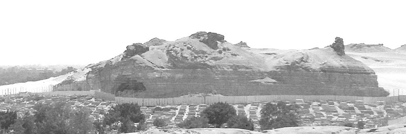
Jutting up very prominently is a large pillar to the right side of Gebel Gibli Hill. This elevated position affords commanding views towards all of the pyramids, the Sphinx and temples of the Giza Plateau. The huge pillar sits due South (180-degrees) from the central platform area atop the Sphinx's back.
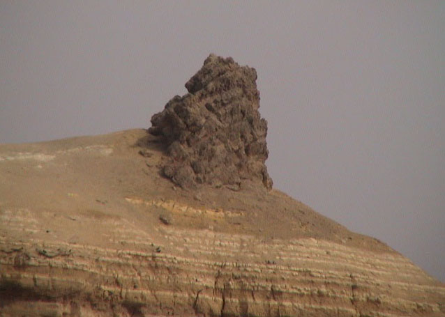
After many thousands of years of being exposed to the harsh elements, the pillar atop Gebel Gibli Hill still retains a certain rugged symmetry, almost as if it was once partially hewn, modified and shaped (like the Sphinx itself) in order to serve the function of an eternal trig or surveyor's marker for the Giza complex of structures.
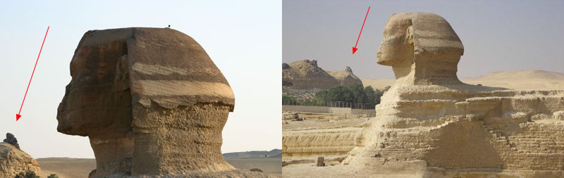
The pillar is in clear view and DUE SOUTH of the Sphinx platform.
The design shape of the Sphinx's rear haunch section provides a clear indication of where a line extending to or from the pillar lies on a precise North-South axis. Likewise, the distance from the pillar's peak to the central haunch section on the Sphinx platform is 1575' or (what eventually became) 2.5 Greek Stadias (630') or exactly 3/10ths of (what became) a Greek mile (5250').
It's important to realise that the fledgling Greek civilisation (like so many others) adopted Weights, Measures and Volume systems that had been earlier used in Egypt. An entire confederation of early Mediterranean and European civilisations shared common, inter-calculable, metrology systems, all based upon the same "inch" and grain weight. This truth will be demonstrated as we proceed.
It's also very important to realise that the "so-called" British Standard foot of 12" is incredibly old and that all of the ancient structures on the Giza Plateau or elsewhere in Egypt were built according to the selfsame inch (incorporated into all the "cubits" or other measurements used by the great cousin civilisations of antiquity).
Alternatively, in the foregoing black and white picture of Gebel Gibli Hill another prominent geological hump feature sits more centrally and was, undoubtedly, used as a surveyor's benchmark also. It's measurable position away from the other pillar could be fixed at, say, 302.4' (3-seconds of Earth Equatorial arc, according to the navigational system incorporated into the base dimensions for one circumnavigation of the Great Pyramid ... 3024' or half a minute of equatorial arc).
The angle running from the apex of Menkaure Pyramid to the centre top of the Great Pyramid is 37. 8-degrees and there is ample room on this second, flat-topped hump to create a precisely measured surveyor's baseline between these two high outcrops on Gebel Gibli Hill and set it out at 37. 8-degrees azimuth.
 .
.
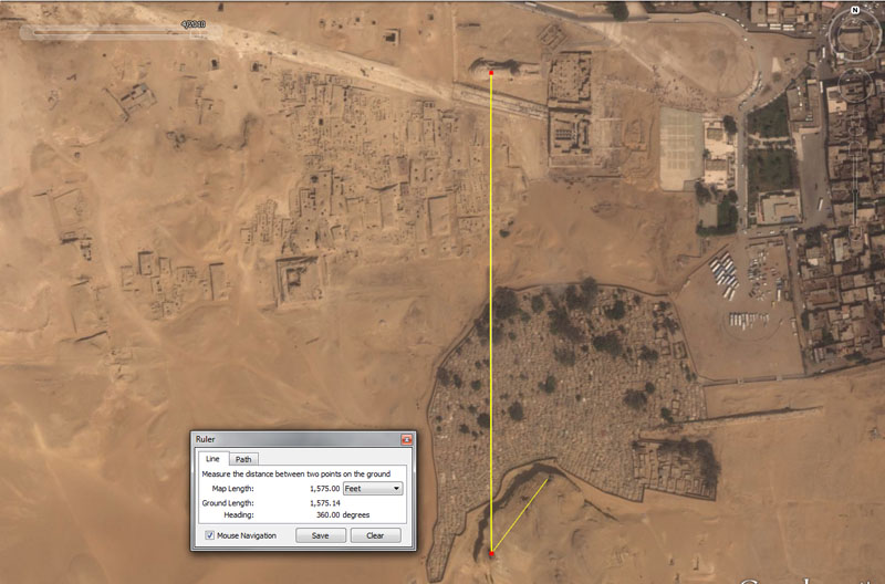
A surveyor's baseline runs at a precisely required, design distance due North from the apex section of the pillar to the platform atop the Sphinx.
The line resolves centrally adjacent to a visually apparent indentation built into the rear haunch section of the Sphinx. From that platform position, ancient surveyors, using alidade sighting rules, could fix upon the Gebel Gibli Hill pillar for precise orientation onto true South. Using plane-tables that incorporated 360-degree disc calibrations, they could then identify the exact degree angle out to any target around the plateau or horizon.
The very old and widely used length of 1575' (British Standard feet) running to the centre of the Sphinx platform, equates to 1500 Greek feet of 12.6" each or 150 Hebrew Reeds of 10.5' each. The same distance would also equate to 750 Assyrian cubits or 900 Hebrew-Celtic royal cubits of 21" each, as well as 1050 Hebrew-Celtic common cubits of 18" each.
It is important to note that the width aspect of the Sphinx, at this point, lends itself to two additional codes. The first of these is a distance of 1570.8' to the southern edge of the platform and the 1570.8 value was for mnemonic reference to PI (in enlarged ratio). PI is 3.1416 and its half value is 1.5708. The Grand Gallery of the Great Pyramid was measured by Petrie to be 157' and one assumes that 157.08' was originally encoded. The same holds true at Stonehenge, where the inner embankment sweep sits an intended 157.08' from site centre.
Another measurement resolves to the northern side of the Sphinx @ 1584'. This is an ever-recurring value in ancient metrology that provides a mathematical progression related to the equatorial diameter of the Earth (7920-miles). The sum of 1584-miles would be 1/5th of the equatorial diameter.
In other words, there were 3 possible stations on this line crossing over the back of the Sphinx and, depending upon what number family or method one wished to do trigonometric calculations in, there were 3 choices of surveyor's baseline lengths at their disposal.
In the above picture, a short yellow line extends from the Gebel Gibli Hill pillar to an adjacent, elevated, natural outcrop platform. The distance shown is 302.4' at an azimuth angle of 37.5-degrees. The Great Pyramid @ 756' per side is, as stated, 3024' for all 4 sides and this value is 1/2 of 1-minute of equatorial arc (6048') for the world. It's unknown what baseline length and angle the original surveyors would have chosen to use between these two Gebel Gibli Hill crown points, but it seems apparent that such a convenient opportunity to establish a baseline would not have been overlooked.
The primary baseline for the site was obviously the one extending to the Sphinx, where surveyors could make trigonometric calculations over the plateau from a station on the Sphinx platform.
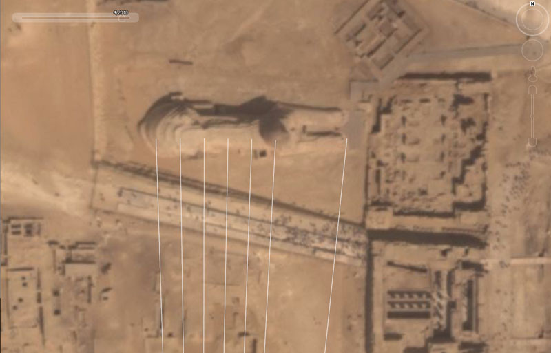
Lines extend from the Gebel Gibli pillar to the back of the Sphinx, head and front paw.
From left to right these angles are: 358, 359, 0, 1, 2, 3 & 6-degrees respectively. Of these resolving stations spread 1-degree apart, all should have been in clear view from the pillar, with the exception of the front paw section, which was hidden below the enclosure wall.
Exercises like this would have been important when teaching trigonometry to ancient students of architecture, surveying and navigation.
The very long an disproportionate body of the Sphinx encoded significant measurements of length, width and height and also functioned admirably as a surveyor's benchmark station for setting out all of the code-bearing structures built on the Giza Plateau.